|
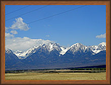
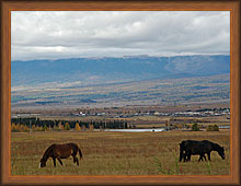
Tunkinskaya valley is a continuation of the Baikal basin
and it is unique in its mineral springs and alpine meadows. From the west
valley is bounded by high mountains of Eastern Sayan with pronounced
alpine landforms and from the east - less steep Hamar-Daban ridge.
Mountains flank the valley starting directly from the flat grasslands of
the valley and climbing to a height of 2500 meters. Already in late
September the mountain peaks are covered with snow and spectacular look at
the background of the not fallen leaves of forest.
Route description
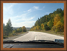
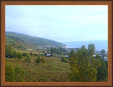
Listvyanka - Irkutsk (70 km). This part of the route
passes along the highway, called Baikal tract. The road goes away from the
coast of the Irkutsk Sea. The water surface becomes visible only in rare
places where the path approaches the bays. Most of the way passes through
the mountains among the dense mixed forests of pine, birch, aspen, and
undergrowth of bushes.
See map...
Irkutsk - Kultuk (100 km). At Irkutsk we cross
the Angara River on Irkutsk hydroelectric dam. After passing through the
city's neighborhoods, we go to the federal highway M-55 "Baikal" (Irkutsk -
Ulan-Ude - Chita). There is Shelekhov town after 18 km. After Shelekhov
road goes through open plains. After 9 km the most beautiful and
interesting site begins. The road contants lot of ups and downs with sharp turns.
The virgin taiga rises closely to both roadsides.
Prior to the Kultuk settlement begins long descent (with long loops) to the coast of Lake Baikal.
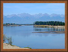
There are two viewing platforms overlooking the picturesque southern part of Lake Baikal.
See map...
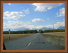
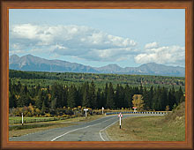
Kultuk - turn to Arshan (87 km). At Kultuk we turn from the
M-55 highway to the road A-164 (Kultuk-Mondy), which leads to the boundary with
Mongolia. First, the road goes along the mountain terrain with a succession
of ups and downs. After several passes we will leave Irkutsk region and
we drive to the territory of the Republic of Buryatia. Distance from Kultuk
to the boundary with Buryatia - 39 km. Almost here Tunkinskaya valley begins.
The road is smooth, without sharp changes in height. Clearly visible
mountains: Khamar-Daman ridge on left and Eastern Sayan - on the right.
From time to time the road is conveniently situated close to the Irkut river.
After 86 km from Kultuk the turn from the A-164 road to the Arshan
settlement is located. There are two options for continuing the trip: to
Arshan or Maly Zhemchug (on the request
of tourists).
See map...
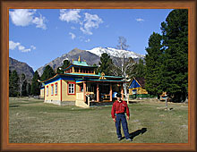
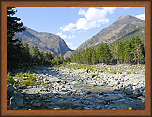
Arshan - a small resort village at the foot of the Eastern
Sayan Mountains at a distance of 28 km from the A-164 road. His fame Arshan
received by mineral springs. The village is surrounded by a beautiful pine
forest. Mountain Kyngyrga river is located near the village. In the
village you can visit the mineral springs, climb mountains and waterfalls
(height falls to 7 m) on the Kyngyrga river and meet with Buddhist datsan.
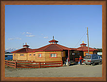
There are two spa and a few private hotels and guest houses.
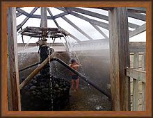
Maly Zhemchug is a village in Tunkinskaya valley on the
banks of the Irkut river. To get to it we drive
another 15 km along the road A-164, then turn to the gravel road and
overcome a further 3 km. There are two thermal source of artificial origin.
Hot mineral water comes from wells drilled for geological surveys.
The first well has a depth of 860 m. It contains methane water of
38oC temperature. The second has a depth of 1,066 m and contains
carbon dioxide water 55oC. In recent years sources have become very popular.
Numerous resort facilities (private hotels and boarding houses, a pavilion with bathrooms,
shower in the open air) were built around the sources.
At your request, you can stay overnight at Arshan or Maly Zhemchug.
Price
The price is contractual and includes:
- rent of car and driver and guide service;
- overnight at the recreation center;
- meals during the tour;
We provide excursions for groups up to 4 persons.
|


)
)
)
)
)
', 'September 14, 2010',800,600))
;)
;)
;)
)
)
)
)
)
)